Highway U.S. 70 from Ruidoso to Roswell is a treasure of a drive, especially in the fall when the cottonwoods, fruit trees and other deciduous vegetation are showing their vibrant yellow, red, orange and rust colors. The landscape is spiked by tall rows of Lombardi poplars outlining property boundaries of small farms and ranches.
It winds alongside the Rio Ruidoso until it meets the Rio Bonito about a third of the way along the route, then the river becomes the Rio Hondo which eventually goes dry most years before feeding into the Rio Pecos below Roswell.
The old two-land highway was very twisty and dangerous to drive, with very flew places where it was straight enough to pass a slower vehicle. Now four lanes most of the way, it passes old haciendas, skirts the tiny and historic old St. Anne’s Episcopal chapel, sweeps by the once grand Tinnie Mercantile store and restaurant and the once infamous White Cat Bar. The towns along the route have memorable names — Glencoe, Hondo, Picacho, San Patricio, Riverside and Tinnie. There’s a turnoff to a ghost town town with what I’ve always thought was one of the prettiest names of any community in the state — Arabela. The town was established in the early 1900s and named by the local postmaster for a Mescalero Apache woman he had become smitten with — Arabela Barela. According to historical sources, Arabela and her two sisters, Damiana and Carolina, ran a local house of ill repute to serve ranch hands and miners in that lonesome outpost on the far eastern tip of the Capitan Mountains.
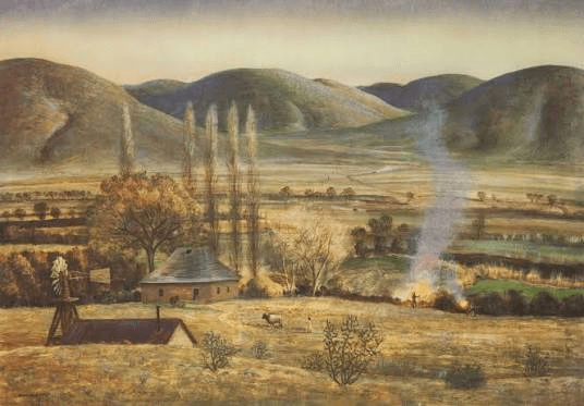
The road also goes though Peter Hurd country, passing his old ranch home where he painted many scenes of the rounded hills surrounding the deep valley.
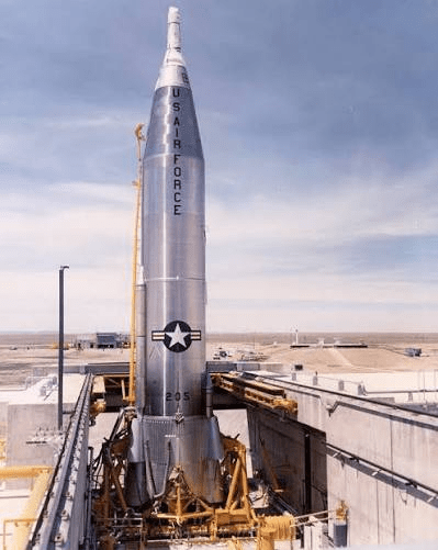
On year, on a drive with my parents from Ruidoso to Roswell, we had just left the Hondo valley at the restaurant/gas station at Riverside, where the highway abruptly turns north up a steep incline to reach the flat plains above. As we crested the hill, one of the most memorable things I ever recall seeing was jutting obscenely upright in the bright sunlight above the flat surrounding terrain.
It was a gleaming silver Atlas missile, which had been elevated from its underground silo for a training exercise. At 83 feet tall towering over the treeless high desert, It was a stunningly unexpected sight.
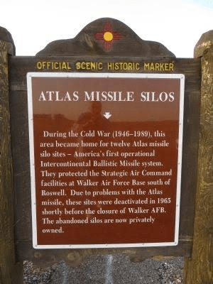
There were 12 of these Atlas missile silos located in eastern Lincoln County and throughout Chaves County, all associated with the former Walker Air Force Base. The New Mexico historical marker below gives a brief description of the silos and their history in that part of our state.
The silos have all been acquired by private interests and some have been turned into underground “airbnb hotels.” Here’s a link to a story about one of them near Roswell:
The silos are about 18 stories deep, and were well equipped for the crew to survive the worst imaginable scenario during a cold war nuclear exchange between Russia and the United States.
What made me think of this was a television commercial I recently viewed in which a UPS or FedEx truck stops to make a delivery in a barren desert landscape with no visible dwelling in the area. The delivery team looks bewildered when suddenly, a manhole cover pops open and a man pokes his head out of an underground silo to announce that this is, indeed, a correct address for the delivery.
I don’t think I’d care to stay in one of these abandoned silos. I’d rather spend the time in a cabin in the mountains watching nature and not thinking about Armageddon.
