I’ll bet that many of you remember 5th or 6th grade geography class, in which we had to remember the names of each state capitol. Montpelier, Vermont, always stood out in my mind, for some obscure reason. So when it came to Arizona, it was always easy to remember Phoenix as the capitol because it was the state’s best known and largest city.
But did you know the Arizona capitol might have been our own humble little town of Mesilla, in New Mexico? Read on.
I did more research about my recent post about how the states of New Mexico and Arizona, along with bits of Colorado and Nevada, were once lumped together in what would have been the largest state in the nation in 1850.
A map I found in a 1969 book entitled Historical Atlas of New Mexico by Warren A. Beck and Ynez D. Haase shed some more light on the transition of our state’s borders.
According to the authors, there was a proposal submitted by President James Buchanan in 1857 to divide the New Mexico territory into two states horizontally, rather than in a vertical fashion that was ultimately finalized in 1875. Below is a copy of the map showing the proposed division of the territory.
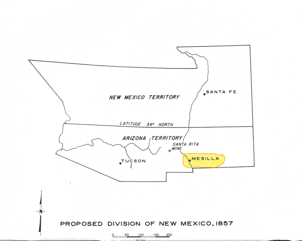
The states would have been divided along the 33 degree 40′ line north latitude. And yes, under that arrangement, the now sleepy little town of Mesilla, highlighted in yellow, would have been the capitol of Arizona.
My friend Lon sent me a message following my original post about why it took so long for New Mexico and Arizona to become states. He discovered this passage in a book entitled Las Cruces by Gordon Owen.
“Stephen B. Elkins (Congressional delegate from New Mexico territory and former Secretary of War) went to congress to lobby for statehood. He walked into congress just as a speaker delivered a barn-storming speech denouncing the KKK and the South in general. The speaker bumbled into Elkins and he, noticing the rousing and approving response, vigorously shook the speaker’s hand. Southerners noticed this and ended any hope of statehood for the next thirty years by only seven votes.”
(More historical drivel you probably didn’t want to know: Elkins began his law practice in Mesilla and served as congressional delegate for New Mexico from 1873 to 1877. He was also a former U.S. District Attorney for the state and was said to have been a member of the infamous “Santa Fe Ring,” which included his brother in law, Thomas B. Catron. Catron, you may remember, was also involved with Albert B. Fall in the Teapot Dome scandal.)
As I had also mentioned earlier, I have read reports that many in Congress did not want Arizona and New Mexico to become part of the union because of the large population of residents of Mexico who lived in the territory and because so many of them preferred to speak Spanish over English.
It’s interesting how boundaries evolved over the years. The Arizona under the 1857 plan would not have been included the Grand Canyon, the red rocks of Sedona, the Navajo Nation and many alpine landscapes. The New Mexico under that plan would have been spectacular, but I’m glad we ended up with the boundaries we have today.
